

欧洲国际大地测量学和地球信息技术展览会(INTERGEO)是世界上最大的大地测量,地理信息和土地管理的交流平台,一年一届,在德国各城市轮流举行。INTERGEO是覆盖了整个行业,汇聚了广度和深度、当前和前瞻性的产品,技术和系统解决方案,是世界上唯一完整范围的展览事件。该展览及会议涵盖所有的作物,沿着整个价值增值链的关键趋势 - 从地缘为基础的信息调查和数据处理,集成的应用程序。因此,它是业内最大,最重要的展览会议。

展品范围涵盖了各方面的测量,地理信息系统,遥感与摄影测量,以及互补的解决方案和共性技术。此外INTERGEO是一个快速发展的创新领域的完美的展示平台。这些未来的技术展示他们的产品和服务组合的OSGeo公园以及在为初创创新园的提供者。 这也是一个最新的创业发展的平台: 使用的传感器系统,以简化复杂的数据采集成功,街车的三维社区记录 - 初步发展,新的或先进的应用,3D应用,卫星/定位服务,对地理网络解决方案的趋势,特别是在重要方面的视角。随着新行业的重要课题,提出了发展趋势及媒体论坛从地缘相关行业的最新需求和解决方案。趋势说明,产品介绍和现场演示,提供了创新和未来市场发展的平台,并强调独特的INTERGEO空间:知识与行动的地球。
今天大地测量学和地球信息技术展览会提供了决策,涉及政治,福利和商业事务的基础。作为一个充满活力的国际市场的支点,INTERGEO与所有区域的链接,为创新的动力和推动在新的业务领域地缘为基础的解决方案的集成了。
INTERGEO展的主题:云计算,测量学,摄影测量,GNSS测量系统,无人机,大数据分析,GIS解决方案,激光扫描,建筑信息建模(BIM),智慧城市。

展品范围(Show Products):
大地测量学、地理信息、遥感与摄影、软件、补充解决方案/共性技术、文学/专业媒体、专业发展、专业协会、媒体合作伙伴。

展会报告(Show Reports):
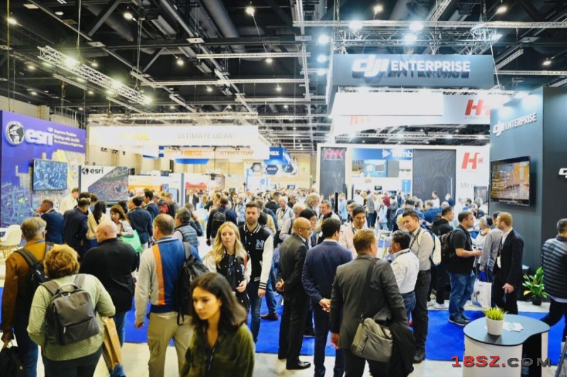
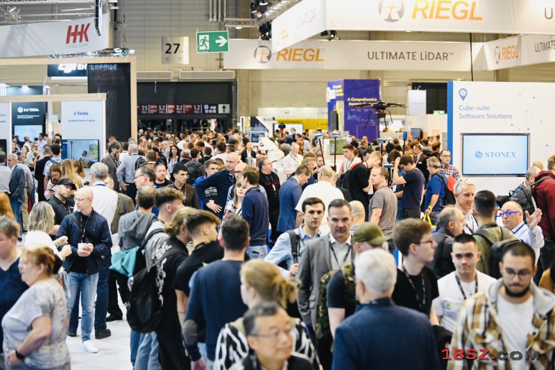
Berlin 12.10.2023. INTERGEO EXPO and ConFERENCE has come to a successful close after three days in Berlin. The leading international trade fair for geodesy, geoinformation and land management presented itself as a magnet for the international geospatial community and for the diverse application areas of geodata-based solutions.
With almost 17.000 trade visitors from 112 nations, 571 exhibitors from more than 40 countries, over 300 speakers and 841 conference participants from 42 countries, INTERGEO EXPO and ConFERENCE once again proved its position today in Berlin: INTERGEO is the world's leading trade fair and most important international congress platform for all aspects of geodesy, geoinformation and land management. As the market leader, INTERGEO brings together the geospatial community and networks it with its industry users. It is the center of the professional community, the face and communicator of the industry.
Prof. Dr. Rudolf Staiger, President of the organizer DVW e.V. (German Association for Geodesy, Geoinformation and Land Management): "The response of the exhibiting companies and the visitors at the EXPO and the feedback from the ConFERENCE participants confirm our concept. We have positioned strong themes such as Earth Observation and Environmental Monitoring, Smart City, BIM (Building Information Modeling) for Infrastructure, Digital Twins, Maritime Solutions, 4D Geodata and 3D Cadastre. These are all elements of geospatial data-based solutions for sustainable development. With this focus, we have struck a nerve."
From global monitoring to local action
A look at the UN's Sustainable Development Goals shows that 80 percent of the 17 goals and 231 indicators, are spatial related, such as the fight against poverty, clean water, clean energy, sustainable cities, climate protection and life on land and under water. Global Earth Observation technologies such as COPERNICUS and GALILEO serve as information providers for local action. EXPO and ConFERENCE have made it clear: "Global Monitoring and Earth Observation are the basis for understanding interrelationships. In these crisis-ridden times and under the impression of global warming, anyone who has to make very local decisions to limit the effects of climate change is dependent on precise spatial information. Our industry provides it," says Staiger.
Jack Dangermond, founder and CEO of the GIS software group Esri, also pointed out the importance and influence of GIS for the path to a sustainable future in his well-received keynote address: "We need to develop a shared understanding of our planet's ecosystem in order to meet the critical challenges of our time. Sustainability begins with geography because it provides a deep understanding of holistic events. GIS as the foundation for Digital Twins enables us to understand impacts, model scenarios, and derive necessary decisions. We must act because we are living beyond our means. Geospatial data is the foundation for generations to come."

Local governments, urban planners, climate researchers, mobility experts, marketeers, farmers and foresters, oceanographers and many others depend on the performance of the geospatial community as user industries. The industry's toolbox is well filled: "Cloud solutions, artificial intelligence, digital twins, BIM, UAV, GIS, Big Data - at INTERGEO we showed what's possible," says the DVW President.
BIM-Days Germany integrated into INTERGEO
The business sectors of design and construction also benefit greatly from the innovations of the geospatial industry. The integration of "BIM-Days Germany" as a platform for the digital construction and building industry shows how the sectors are growing together. "Geodesy is the natural partner of the construction industry and architecture. It is an integral part of the planning and construction processes and elementary for sustainable, CO2-neutral construction," says Dr. Josef Kauer, initiator of BIM-Days Germany. On the BIM stage and in the BIM cinema, visitors to INTERGEO were updated on topics such as how LIDAR technologies optimize the BIM process and how BIM is becoming the standard in infrastructure construction.
German Cartography Congress
The 71st German Cartography Congress (DKK), which was integrated into INTERGEO, added additional highlights with topics such as generalization with machine learning and artificial intelligence, maps for mobile use and hazard maps. "Cartography is the extended arm of the geospatial industry. We bring the results of earth observation and data acquisition to a broad audience," said Prof. Dr. Jochen Schiewe, president of the organizer, the German Cartographic Society.
Youth development and training
The geodesy, geoinformation and land management sectors, which are strongly influenced by the engineering sciences, are intensively engaged in recruiting young talent and specialists. DVW e.V. offers access to the working world of the geospatial industries via the platform "Arbeitsplatz Erde" and the social media brand "Weltvermesserer". DVW e.V. used INTERGEO EXPO and ConFERENCE for intensive campaigns for young people. The school day alone brought numerous interested students into contact with the working world of the geo-community. The awards for final theses at the Geodesy Prize and the Promotion Prize also count towards the promotion of young talents.
Organizers very pleased: market position expanded
The share of international exhibitors and trade visitors as well as the presence of the World Geospatial Council (WGIC), the international non-profit association of the geospatial industry, at the EXPO are proof of this development. DVW president Staiger: “We’ve seen a high level of international participation in EXPO and CONFERENCE, which shows us we’re expanding our market position internationally as well.”
The organizer’s summary: “We are very satisfied with the result of INTERGEO. The response from exhibitors, EXPO visitors and ConFERENCE participants was overwhelming.”
Exhibitor comments confirm the general image. Professor Gerd Buziek, Business Relations Executive of Esri Deutschland, summed up his enthusiasm for INTERGEO: "INTERGEO is the face of the industry. Thank you for that." Thomas Harring, President of Hexagon Geosystems Division, is equally enthusiastic: "A great show that demonstrates what our industry does." Dr. Felix Reinshagen CEO of NavVis: "Great to see how strong INTERGEO has come back after the COVID period. Everyone is back and we were very busy." Scott Crozier, Vice President Survey and Mapping at Trimble: "I'm already looking forward to Stuttgart."
The DVW President evaluates the new IN-ConFERENCING program with its practice-oriented content to be very positive. "It shows that the visitors to the EXPO also want much more than a technology show. We addressed them at the EXPO stages with topics such as Digital Twins, Geodata Collection, BIM, UAV, marketing and attracting young talent, and the concept has worked," says Staiger.
INTERGEO 2024 in Stuttgart
Many of the exhibitors have already booked their participation for next year. From September 24 to 26, 2024, the leading platform of the geospatial community will present its innovations in Stuttgart. Geoinformation will continue to be the driver of innovation in administration, business and science.